INTRODUCING
BOOKINGS ON WIKICAMPS
Standley Chasm
 Point of Interest
Description
Migrating birds
Take an easy stroll back in time to experience the dramatic natural beauty of Standley Chasm
Traditionally known as Angkerle Atwatye, this is an important cultural place, sacred to our womens dreaming. Standley Chasm ANGKERLE is 100% Aboriginal owned and operated, supporting the local Arrernte community.
Located 51km by sealed road, just 30 mins drive west of Alice Springs, Standley Chasm has been gouged through tough sandstone by the floods that over untold millions of years. They have surged down a narrow tributary of the Finke river system. Today the result is a deep red cleft in the West MacDonnell Ranges crowded on either side by craggy slopes that rise 80 metres above the floor.
Standley Chasm is located in a private flora and fauna reserve owned by the Iwupataka Land Trust and is operated by the Traditional Owners of this unique site. As a local community owned tourist enterprise, Angkerle Aboriginal Corporation can assure a reliable and authentic Arrernte experience, with professional catering services provided in a tranquil bush setting, as we want to share with our visitors this special place that we have cherished for generations.
Park your vehicle up in our spacious car-park, freshen up in the clean amenities & come visit us in the KioskCafe to get an access ticket for the Chasm.
Most active visitors will find the 1.2km/ 15min each way walk to be reasonably easy, as the path has been upgraded to a Grade 1 Access path, accessible by wheelchair. However, the natural conditions, some rough surfaces would require that sensible shoes be worn and care taken.
On the way there or back, note the unusual features of the natural landscape here, the unique micro climate in this valley has created some distinctive features, such as ancient Cycads and a myriad of rock types and pebbles that are thousands of years old, washed down from miles upstream.
Sections 3 & 4 of the Larapinta Walking Trail, which are highly recomme
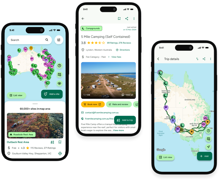
Find this site and more on WikiCamps
Take the ultimate camping companion on your next trip, with these great features:
![]() Explore more than 60,000 sites across Australia with detailed site information at your fingertips
Explore more than 60,000 sites across Australia with detailed site information at your fingertips
![]() Stay in the know with exclusive, insightful reviews from fellow travellers
Stay in the know with exclusive, insightful reviews from fellow travellers
![]() Map journeys, plan your route, and gauge your fuel spend with Trip Planner
Map journeys, plan your route, and gauge your fuel spend with Trip Planner
![]() No signal? No worries! Use offline mode to travel anywhere with WikiCamps
No signal? No worries! Use offline mode to travel anywhere with WikiCamps
![]() Add sites to your collections, search with intuitive filters, and so much more...
Add sites to your collections, search with intuitive filters, and so much more...
Get WikiCamps now!
Download WikiCamps from the App Store on your device.

