INTRODUCING
BOOKINGS ON WIKICAMPS
Kalpowar Crossing
 Campground
Description
All camping in Rinyirru (Lakefield) National Park (CYPAL) must be booked in advance. Campers must purchase an e-permit before arriving at the camping areas. Self-registration is not available and there is no mobile phone coverage on site (there is limited mobile phone coverage near the New Laura ranger base).
To obtain an e-permit, you can:
- book online
- visit an over-the-counter camping permit booking office or self-service kiosk
- phone 13 QGOV (13 74 68). Mobile phone charges may apply.
Kalpowar Crossing camping area is on the very steep (>5m high) western bank of the Normanby River adjacent to an 8km stretch of permanent fresh waterholes. This camping area offers the most facilities and is popular with locals and travellers alike. This is the only point vehicles can cross the Normanby River to access Cape Melville National Park. Large crocodiles are frequently seen here.
The camping area can be reached by four-wheel-drive vehicle only. It is not accessible for campervans or buses. The road becomes impassable after rain. If choosing to travel with a caravan, check road conditions before travelling (see Cook Shire Council road conditions).
There are 15 unpowered numbered sites for general use and four numbered sites for commercial operators only (sites 16-19).
Facilities include hybrid toilets, cold showers, taps (treat water before drinking) and individual fire rings.
Camp fires are allowed, except when fire bans apply. Fire rings should be used when provided. Do not collect firewood in the national park. Always put the fire out with water when you leave your camp site and obey fire restrictions and directions from rangers.
No generators and no pets.
Rinyirru (Lakefield) National Park (Cape York Peninsula Aboriginal Land (CYPAL)) is closed throughout the wet season every year from 1 December to 30 April. All camping areas north of the Lakefield ranger base (see detailed camping information) remain closed up to and including 31 May. These dates may vary depending on weather and road conditions and camping areas and roads may also be closed after heavy rain.
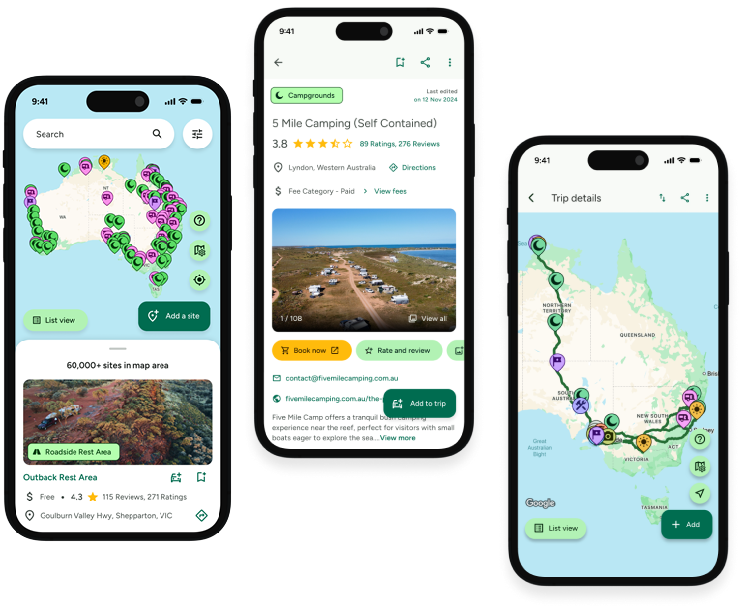
Find this site and more on WikiCamps
Take the ultimate camping companion on your next trip, with these great features:
![]() Explore more than 60,000 sites across Australia with detailed site information at your fingertips
Explore more than 60,000 sites across Australia with detailed site information at your fingertips
![]() Stay in the know with exclusive, insightful reviews from fellow travellers
Stay in the know with exclusive, insightful reviews from fellow travellers
![]() Map journeys, plan your route, and gauge your fuel spend with Trip Planner
Map journeys, plan your route, and gauge your fuel spend with Trip Planner
![]() No signal? No worries! Use offline mode to travel anywhere with WikiCamps
No signal? No worries! Use offline mode to travel anywhere with WikiCamps
![]() Add sites to your collections, search with intuitive filters, and so much more...
Add sites to your collections, search with intuitive filters, and so much more...
Get WikiCamps now!
Download WikiCamps from the App Store on your device.

