INTRODUCING
BOOKINGS ON WIKICAMPS
Gorrell Trailhead (Eastern)
 Point of Interest
Description
Start of three walks- Gorrell, McNamee Creek and Cardwell Range.
Travel 20km south to Mena Creek, then take Mena Creek Road (partially sealed) 10km to the Gorrell trailhead (eastern).
The Gorrell (storm bird) track takes you through the Downey Creek catchment. The Downey Creek area has been used by the Australian army to test the durability of military equipment in tropical conditions. King ferns, bunya pines, epiphytes and giant strangler figs are features of the forest in this area.
Distance: 25.7km one way
Time:
Walkers: 2.5 days one way (approx 8hrs per day)
Mountain bikers: 510hrs one way
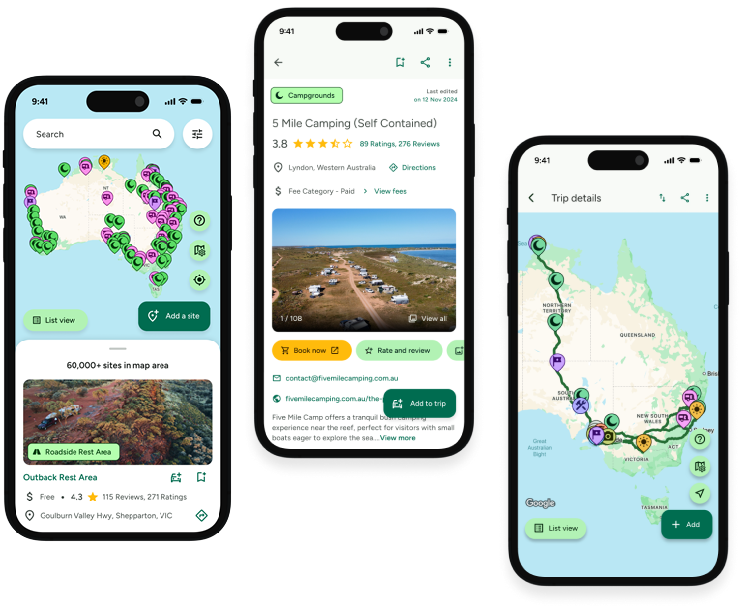
Find this site and more on WikiCamps
Take the ultimate camping companion on your next trip, with these great features:
![]() Explore more than 60,000 sites across Australia with detailed site information at your fingertips
Explore more than 60,000 sites across Australia with detailed site information at your fingertips
![]() Stay in the know with exclusive, insightful reviews from fellow travellers
Stay in the know with exclusive, insightful reviews from fellow travellers
![]() Map journeys, plan your route, and gauge your fuel spend with Trip Planner
Map journeys, plan your route, and gauge your fuel spend with Trip Planner
![]() No signal? No worries! Use offline mode to travel anywhere with WikiCamps
No signal? No worries! Use offline mode to travel anywhere with WikiCamps
![]() Add sites to your collections, search with intuitive filters, and so much more...
Add sites to your collections, search with intuitive filters, and so much more...
Get WikiCamps now!
Download WikiCamps from the App Store on your device.

